At the recent Alpine Glaciology Meeting (AGM) 2016 held in Munich we presented some of the ongoing work in the Langtang catchment.
Pascal Egli presented his work on the reconstruction of debris thickness on debris covered glaciers from thermal satellite images and meteorological data via an energy balance approach. We used three previously published methods based on the energy balance to compute debris thickness maps of Lirung Glacier, assess their performance and determined their sensitivity to several input parameters. We developed a new time-integrating energy balance model with which we intend to obtain more accurate estimates of debris thickness by accounting for the heat transport and storage in the debris layer. Debris thickness reconstruction is essential for the determination of melt rates of debris covered glaciers in the Himalayas.
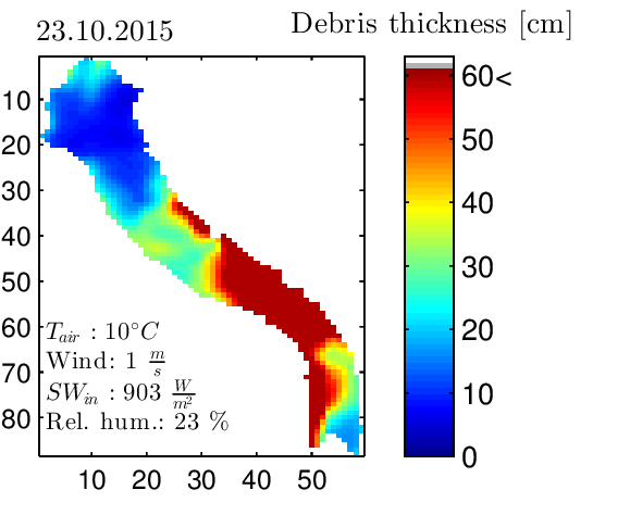
Figure 1: Modelled debris thickness on Lirung Glacier using an energy-balance approach, with distributed surface temperature data from a Landsat 8 image from 23rd October 2015.
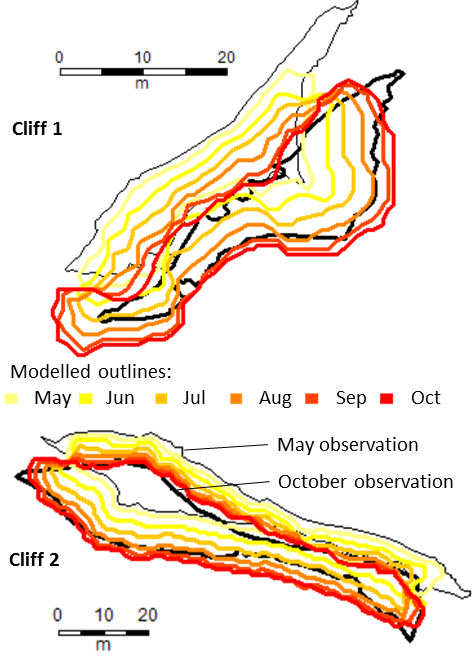
Pascal Buri presented a new 3D-modelling approach of ice cliff backwasting. Whereas some supraglacial cliffs remain stable in terms of shape over the melting season, some cliffs flatten considerably and disappear. We tested our physically-based model on selected cliffs on Lirung Glacier in order to simulate cliff evolution over one season. Both atmospheric melt and the interaction with adjacent lakes and debris slopes are implemented. This allows us to dynamically simulate the cliff geometry applying monthly geometric corrections. Simulated volume losses and melt rates for each cliff roughly agree with a TIN-approach used for validation but give also further insight into the inter-annual variability of melt processes and mechanisms behind cliff dynamics.
Jakob Steiner talked about traces of the Gorkha earthquake from April 2015 left on the cryosphere in the catchment. We could observe that the ice released mainly came from the top ridges pointing at topographic amplification playing a possibly significant role in this case. This could help to assess which hanging ice seracs pose a danger in future earthquakes. The massive deposits on the glacier tongues of two debris covered glaciers in the catchment, could provide a chance to observe how the heterogeneous debris cover develops over time.