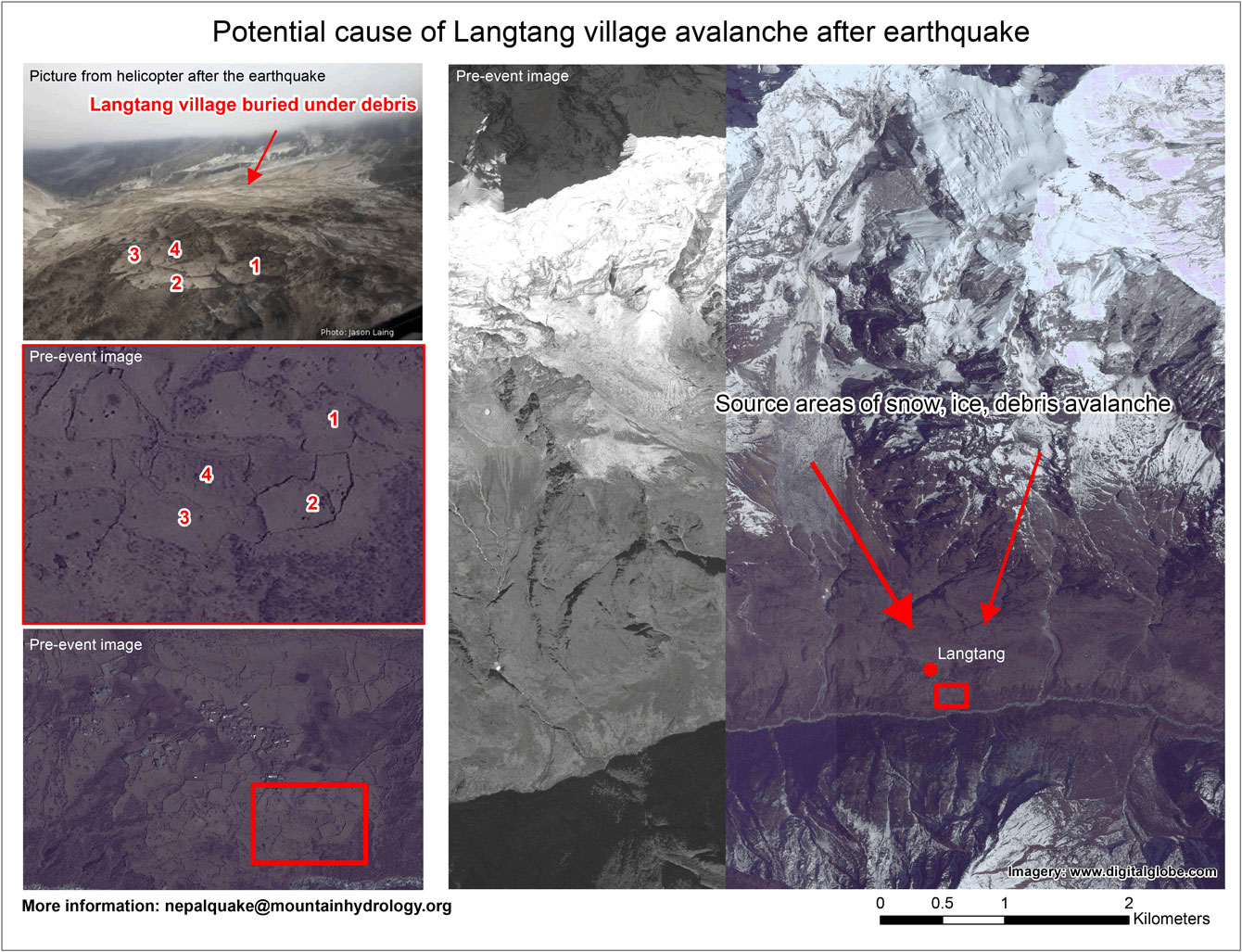
The magnitude 7.8 Gorkha earthquake that struck Nepal on April 25, 2015, caused extensive damage in Kathmandu Valley and severely affected Nepal’s rural areas. The Langtang Valley in the Rasuwa district was particularly hard hit, as became apparent after pictures taken by a rescue helicopter mission on April 26 (link). Numerous tourists and Nepali were, or are still trapped in the valley as road access is completely blocked by avalanches and landslides. The valley’s main village, Langtang , was completely destroyed by the earthquake, including a large, wet, debris- and ice-rich avalanche that has caused an unknown number of casualties. Other avalanches also struck elsewhere in the valley.
Space agencies around the world are providing extensive resources in a huge international effort. They are tasking their satellites to observe the areas hit by the earthquake, beginning immediately after the disaster in Nepal took place. Imaging initially focused on Kathmandu. Following the first social media reporting of the helicopter pilot’s comments, an emergency NASA-USGS-interagency Earthquake Response Team alerted satellite mission operations teams about the likely serious plight of Langtang and other Himalayan valleys. Advisories were also delivered to Nepal officials. The first relief missions arrived in the Langtang Valley about April 28.
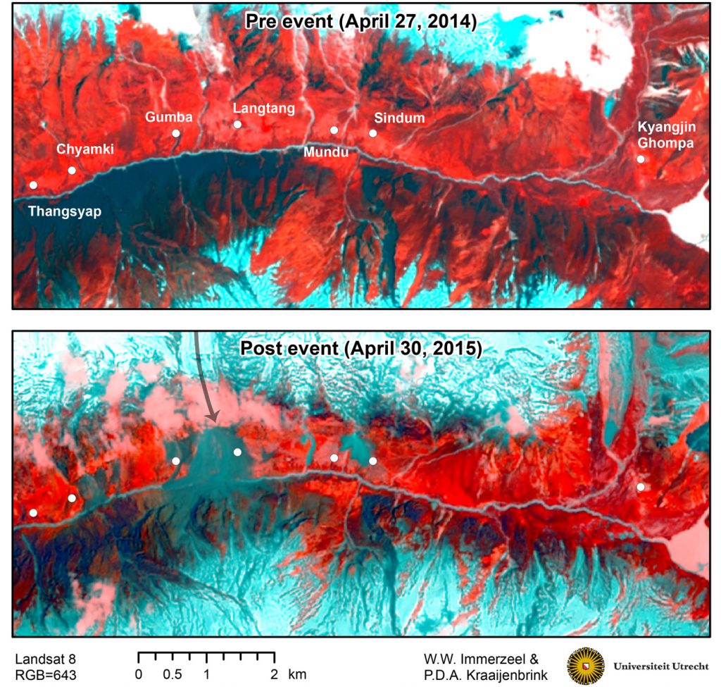
United States Geological Survey/NASA Landsat-8 satellite observations were initially obscured by clouds, but on April 30, Landsat 8 acquired the first largely cloud-free image of the Langtang Valley. Scientists Walter Immerzeel and Philip Kraaijenbrink, both affiliated to Utrecht University in the Netherlands (and Immerzeel also with the International Centre of Integrated Mountain Development in Kathmandu), analyzed the imagery and compared it with pre-earthquake imagery from a year earlier. Their analyses revealed the true extent of the disaster that took place in the Langtang Valley. Langtang village was completely buried by a very large avalanche that originated from the glacier and snowfields on the northwestern slopes above the village. Large landslides or avalanches are also observed near the villages of Chyamki, Gumba, Mundu and Sindum. The avalanches reach to the margins of those villages. The extent of the damage around these small settlements will require further investigation using higher resolution imagery to be obtained from satellites, and word from relief crews on the ground. The area around Kyanjin Gompa seems to be relatively intact. The river at the Langtang village avalanche appears to be blocked, but there is no evidence yet of a lake forming behind the blockage. This may indicate that the water has found its way through the debris, snow and ice. The valley is vulnerable to secondary events such as mudslides and debris and ice avalanches; this situation could continue into the coming monsoon. will continue to monitor this situation closely using satellite data.
These scientists are part of an international volunteer group of 35 members led by University of Arizona scientists Jeffrey Kargel and Gregory Leonard, who launched the group soon after the earthquake occurred. This effort has been incorporated into the NASA-USGS-interagency Earthquake Response Team. Their goal is to systematically investigate the entire quake-affected area using remote sensing. Their results will support relief operations and identify secondary hazards, such as glacier lake outbursts, rivers blocked by landslides, and other unstable areas. This is the first volunteer report of the project.
For more information contact us on nepalquake@mountainhydrology.org
Download PDF version of map
To have look at the data interactively please download this KMZ file, which can be opened in Google Earth
You may also like
There is a great demand of supporting spatial data and accurate maps to guide relief work in the areas most affected by […]
The earthquake of 25 April has presumably triggered a large avalanche / landslide which has buried the Langtang village under debris. On […]