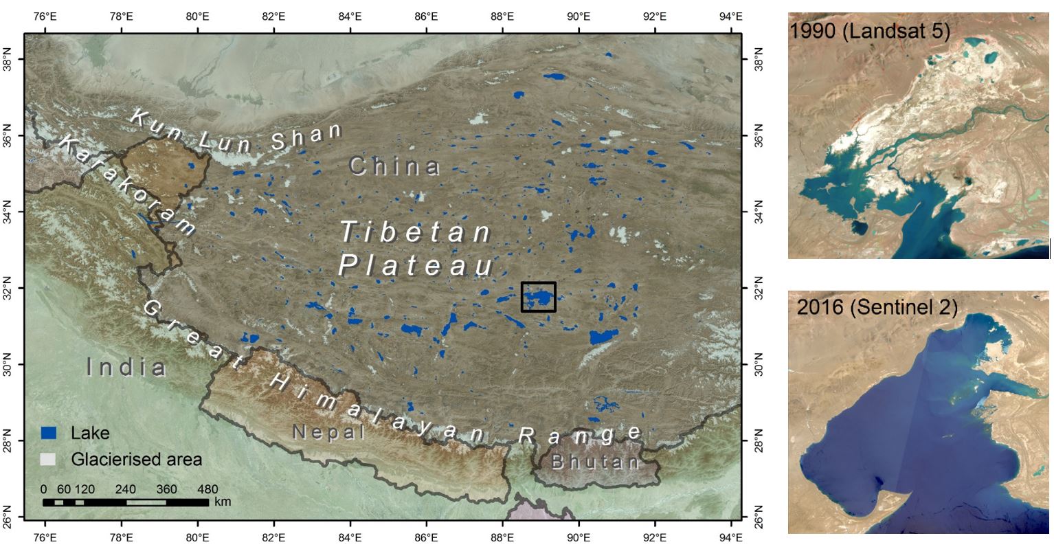
The Tibetan Plateau (TP) plays an essential role in the water supply to Asia’s large river systems and, as the largest and highest mountain plateau in the world, it drives the Asian monsoon and influences global circulation patterns significantly. Climate change is hitting the TP harder than elsewhere, which will affect the water cycle and may impact millions of people living downstream. The TP contains many large lakes that are not connected to the river system and which have undergone extreme water volume changes in recent decades. These so called endorheic lakes can therefore be seen as a gauge of global warming because the strong trends in lake volume can only be explained by climate induced changes in their closed drainage basins.
The Tibetan Plateau is essential for water supply to Asia’s large river systems
Objectives
In this study we aim to disentangle the main drivers of change in the lake water cycle. More specifically, we aim to quantify and attribute the enigmatically rapid changes in Tibet’s lakes to glacier melt, precipitation and evaporation shifts, and/or permafrost changes
The main objective will be addressed through four specific objectives:
- To classify TP lakes and drainage basins and to quantify lake and glacier volume changes
- To understand shifts in the lake basin precipitation and evaporation as driver of lake change
- To elucidate whether permafrost degradation may result in changes of lake water supply and lake volumes
- To upscale and understand key drivers of lake changes for the Tibetan plateau as a whole
Approach
We will set the baseline and delineate the lakes and their lake drainage basins (LDB), classify the lake type, assess changes in lake volume and relate it to potential glacier changes in their LDB. The analyses will be conducted for the entire plateau at unprecedented resolution. To enable this we will, among other things, make use of the Google Earth Engine to provide access to the required computing power and the full Landsat and Sentinel archives.
We will investigate whether shifts in the surface water balance may explain the observed glacier lake volume changes, by focusing on quantification of the differences between precipitation and evaporation (P-E) within each LDB. We will do this both at the large scale, but also for selected lakes, where we investigate seasonal variation based on field observations.
Changes in the permafrost thaw cycle result in a changed water supply to the lakes. We will therefore aim to detect possible changes in permafrost distribution at the large scale, assess the permafrost dynamics in selected LDBs, and will develop a new distributed model to assess hydrological impacts of permafrost degradation.