The greater Himalayas provide a vital water supply for millions people, and as a result climatic change in the source areas of Asia’s main rivers will have a great societal impact. Not only are the Himalayan water resources a crucial asset, but the steep terrain in combination with extreme climatic conditions cause frequent natural disasters, such as landslides, floods and glacier lake outbursts. The hydrology of the greater Himalayas is only marginally resolved due to the intricacy of monsoon dynamics, the poorly quantified dependence on the cryosphere and the physical constraints of doing research in high-altitude and generally inaccessible terrain. The main reason for the current lack of understanding about the future of Himalayan glaciers and downstream water resources is the huge scale gap that exists between studies of individual glaciers that are not representative of the entire region and hydrological modelling studies that represent the variability in Himalayan climates.
Objectives
The overall aim of the “Climbing the Asian Water Tower (CAT)” project is to identify and quantify regional differences in greater Himalayan glacio-hydrology and to elucidate climate change induced alterations in water availability and the occurrence of extreme precipitation events through three key objectives:
- Advance the knowledge on high-altitude climate dynamics from valley to synoptic scales, with a special focus on high-altitude precipitation and the interaction between the atmosphere, the extreme topography, the land surface and the cryosphere
- Understand how climate controls key glacio-hydrological processes in high-altitude catchments in particular ice flow and melt dynamics of debris covered glaciers, snow maturation and sublimation and routing of (sub-surface) runoff.
- Explain regional differences and their consequences for accurate projections of future changes in greater Himalayan glacio-hydrology by implementing catchment scale glacial-hydrological models for two representative, but contrasting catchments at a resolution that allows inclusion of key local-scale glacio-hydrological processes and atmospheric dynamics.
Approach
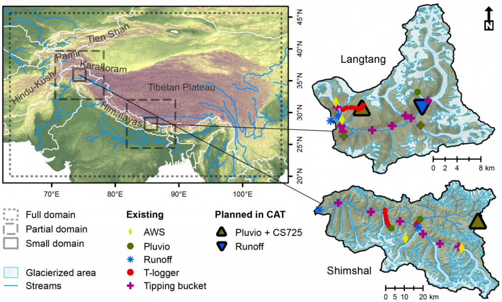
In CAT a team of 4 researchers addresses those objectives by setting-up novel high resolution atmospheric models and by acquiring field data on snow, rain, runoff and glacier properties. Additionally, drone and satellites provides remotely sensed data that is combined with the model outputs and in situ data. All will be integrated into catchment scale glacio-hydrological models. The research will be executed in two contrasting catchment in the Karakoram and the Himalayas.